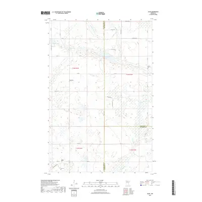
2019 Map of Alida
USGS Topo · Published 2019About this map
Alida serves as a central point in this northern Minnesota landscape where the headwaters of the Mississippi River and the Little Mississippi River weave through a terrain dense with glacial lakes. The settlement pattern is defined by rural crossroads and section-line roads like Co HWY 2 and Co HWY 36, connecting scattered farmsteads and local landmarks. For genealogists and local historians, the map identifies several key burial sites, including the Alida Cem near the townsite and the more remote Moose Creek Township Cem and Jones Township Cem. This 2019 survey also shows the transition between Clearwater, Beltrami, and Hubbard counties. The presence of the Mallard Grade Trl suggests a repurposed transportation corridor, likely following an old rail grade or logging route, reflecting the region's historical timber and transit foundations.
Find a feature on this map
41 named features on this map. Tap any name to fly to it.
Don’t see what you’re looking for? This feature index may not catch every label — zoom into the map to look around manually.
Map Details
Editions of this 2019 Alida Map
This is the sole edition of this map. No revisions or reprints were ever made.
Other maps of this area

1919 · Solway
USGS Topo · 1:62,500

1943 · Solway
USGS Topo · 1:62,500

1943 · Bagley
USGS Topo · 1:62,500

1954 · Bemidji
USGS Topo · 1:250,000

1957 · Bemidji
USGS Topo · 1:250,000

1958 · Bemidji
USGS Topo · 1:250,000

1969 · Shevlin
USGS Topo · 1:24,000

1969 · Heart Lake
USGS Topo · 1:24,000
1969 · Upper Rice Lake
USGS Topo · 1:24,000

1972 · Alida
USGS Topo · 1:24,000