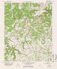
1952 Map of Allegre
USGS Topo · Published 1982About this map
Pond River and its intricate tributaries, such as Slim Jimmy Branch and Wolf Branch, carve through the rural landscape of Todd County in this early 1950s survey. The area is defined by a network of small, scattered farming communities and local landmarks that speak to the region's genealogy. Settlements like Allegre and Liberty serve as anchors for the surrounding countryside, which is dotted with numerous family-named cemeteries including Kirkman Cem, Slaughter Cem, and Simons Cem. Religious life is central to the community's layout, evidenced by the strategic placement of Mt Tabor Ch, Tabernacle Ch, and Collier Spring Ch. The topography is marked by distinct valleys like Dead Man Hollow and Happy Hollow, illustrating the diverse terrain that influenced the original road placements and homestead locations before mid-century modernization. This map records the late-agrarian character of the Kentucky countryside just after the war.
Find a feature on this map
34 named features on this map. Tap any name to fly to it.
Don’t see what you’re looking for? This feature index may not catch every label — zoom into the map to look around manually.
Map Details
Editions of this 1952 Allegre Map
3 editions found
Other maps of this area

1911 · Drakesboro
USGS Topo · 1:48,000

1912 · Nortonville
USGS Topo · 1:62,500

1913 · Drakesboro
USGS Topo · 1:62,500

1950 · Pembroke
USGS Topo · 1:24,000

1950 · Olmstead
USGS Topo · 1:24,000

1951 · Pembroke
USGS Topo · 1:24,000

1951 · Elkton
USGS Topo · 1:24,000

1951 · Olmstead
USGS Topo · 1:24,000

1952 · Sharon Grove
USGS Topo · 1:24,000

1952 · Allegre
USGS Topo · 1:24,000