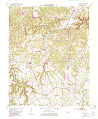
1952 Map of Allegre
USGS Topo · Published 1985About this map
The Pond River snakes through the center of this Todd County landscape, carving a deep valley that defines the local geography between Allegre and the higher ridges to the east. By the early 1950s, the area remained characterized by a network of rural churches and family burial grounds that serve as critical markers for local genealogy. Significant sites include Mt Tabor Ch, College Spring Ch, and Tabernacle Ch, alongside smaller landmarks like Slaughter Cem and Porter Cem. The terrain is deeply etched by a complex drainage system, including Clifty Creek, Sulfur Lick Creek, and the aptly named Dead Man Hollow. A later 1980s update adds modern infrastructure, such as a Radio Tower, while the primary settlement patterns at Clifty and Cedar Grove remain tied to the ridge-and-hollow topography.
Find a feature on this map
30 named features on this map. Tap any name to fly to it.
Don’t see what you’re looking for? This feature index may not catch every label — zoom into the map to look around manually.
Map Details
Editions of this 1952 Allegre Map
3 editions found
Other maps of this area

1911 · Drakesboro
USGS Topo · 1:48,000

1912 · Nortonville
USGS Topo · 1:62,500

1913 · Drakesboro
USGS Topo · 1:62,500

1950 · Pembroke
USGS Topo · 1:24,000

1950 · Olmstead
USGS Topo · 1:24,000

1951 · Pembroke
USGS Topo · 1:24,000

1951 · Elkton
USGS Topo · 1:24,000

1951 · Olmstead
USGS Topo · 1:24,000

1952 · Sharon Grove
USGS Topo · 1:24,000

1952 · Allegre
USGS Topo · 1:24,000