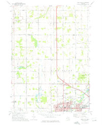
1973 Map of Alma North
USGS Topo · Published 1976About this map
The Alma city center and the campus of Alma College anchor the southern edge of this mid-1970s survey, illustrating the community's development along the Pine River. Industrial landmarks like the Refinery and infrastructure such as the Chesapeake and Ohio railroad corridor contrast with the residential and institutional presence of the Masonic Home and Hospital. Beyond the city limits, the landscape transitions into a grid of rural township roads, including Summerton Road and Shepherd Road, which connect smaller settlements like Forest Hill and Elwell. Numerous family and community landmarks are scattered throughout the countryside, from the Brady Cem and Wright Cem to local spiritual centers like St Johns Ch and Twin Cities Ch. Waterways including Salt Creek and Honeyoey Creek wind through the agricultural sections, while a Landing Strip (Abandoned) east of the river indicates changing land uses near the St. Louis corporate boundary.
Find a feature on this map
98 named features on this map. Tap any name to fly to it.
Don’t see what you’re looking for? This feature index may not catch every label — zoom into the map to look around manually.
Map Details
Editions of this 1973 Alma North Map
This is the sole edition of this map. No revisions or reprints were ever made.
Other maps of this area

1916 · Mount Pleasant
USGS Topo · 1:62,500

1919 · Mount Pleasant
USGS Topo · 1:62,500

1930 · Shepherd
USGS Topo · 1:48,000

1935 · Alma
USGS Topo · 1:62,500

1936 · Shepherd
USGS Topo · 1:62,500

1938 · Alma
USGS Topo · 1:62,500

1943 · Mount Pleasant
USGS Topo · 1:62,500

1954 · Midland
USGS Topo · 1:250,000

1958 · Midland
USGS Topo · 1:250,000

1959 · Midland
USGS Topo · 1:250,000