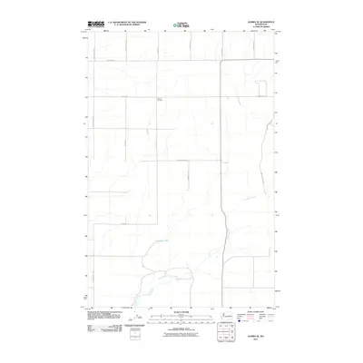
2011 Map of Almira SE
USGS Topo · Published 2011About this map
Tolonen Cemetery sits at the center of this Lincoln County landscape, a marker of early families amidst the vast agricultural grid of eastern Washington. The terrain is defined by the ephemeral flow of Canniwai Creek and its unnamed tributaries, which carve subtle coulees through the high plateau. The road network follows a strict sectional survey pattern, with family names such as Emil Johnson Rd N, Kuchenbuch Rd E, and Govan Rd N preserved in the local infrastructure. In the southern portion of the quadrangle, Carpenter Lake appears as a key hydrological feature, while the winding path of Rock Bottom Loop breaks the geometric regularity of the wheat fields to the east. This 2011 survey captures the area's enduring rural character, where land use remains centered on large-scale dryland farming and scattered homesteads.
Find a feature on this map
18 named features on this map. Tap any name to fly to it.
Don’t see what you’re looking for? This feature index may not catch every label — zoom into the map to look around manually.
Map Details
Editions of this 2011 Almira SE Map
This is the sole edition of this map. No revisions or reprints were ever made.
Other maps of this area

1953 · Ritzville
USGS Topo · 1:250,000

1959 · Ritzville
USGS Topo · 1:250,000

1965 · Ritzville
USGS Topo · 1:250,000

1968 · Marlin
USGS Topo · 1:24,000

1968 · Pacific Lake
USGS Topo · 1:24,000

1968 · Sullivan Lake
USGS Topo · 1:24,000

1969 · Almira
USGS Topo · 1:24,000

1969 · Almira SE
USGS Topo · 1:24,000
1969 · Almira SW
USGS Topo · 1:24,000

1969 · Govan
USGS Topo · 1:24,000