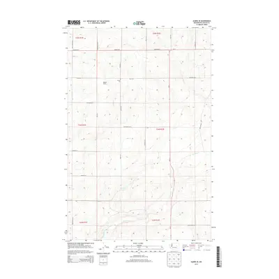
2013 Map of Almira SE
USGS Topo · Published 2013About this map
Tolonen Cem stands as a quiet reminder of early settlement patterns in this corner of Lincoln County, located just north of Field Rd E. The landscape is defined by the high plateau of the Columbia Basin, marked by distinctive drainage features such as Gibson Draw. The rural road network, including Govan Rd N and Monson Rd E, follows the rigid lines of the Public Land Survey System, carving the terrain into neat sections.
Find a feature on this map
30 named features on this map. Tap any name to fly to it.
Don’t see what you’re looking for? This feature index may not catch every label — zoom into the map to look around manually.
Map Details
Editions of this 2013 Almira SE Map
This is the sole edition of this map. No revisions or reprints were ever made.
Other maps of this area

1953 · Ritzville
USGS Topo · 1:250,000

1959 · Ritzville
USGS Topo · 1:250,000

1965 · Ritzville
USGS Topo · 1:250,000

1968 · Marlin
USGS Topo · 1:24,000

1968 · Pacific Lake
USGS Topo · 1:24,000

1968 · Sullivan Lake
USGS Topo · 1:24,000

1969 · Almira
USGS Topo · 1:24,000

1969 · Almira SE
USGS Topo · 1:24,000
1969 · Almira SW
USGS Topo · 1:24,000

1969 · Govan
USGS Topo · 1:24,000