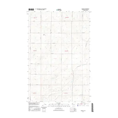
2017 Map of Almira SE
USGS Topo · Published 2017About this map
Tolonen Cem stands as a quiet legacy of early settlement in this corner of Lincoln County, situated near the intersection of Field Rd and Govan Rd N. The landscape is defined by the drainage patterns of the Columbia Plateau, where Gibson Draw cuts across the northern reaches and Canniwai Cr meanders through the southern sections. This 2017 survey reveals a grid-heavy network of rural thoroughfares, such as Monson Rd and Kuchenbuch Rd, which connect remote farmsteads and agricultural tracts. Evidence of the region's unique geology is visible near Carpenter Lake, a notable water feature in an otherwise arid and seasonally varied terrain. The map provides a contemporary view of these traditional land divisions, preserving the names of local families through landmarks like McMichael Rd and Schweda Rd.
Find a feature on this map
34 named features on this map. Tap any name to fly to it.
Don’t see what you’re looking for? This feature index may not catch every label — zoom into the map to look around manually.
Map Details
Editions of this 2017 Almira SE Map
This is the sole edition of this map. No revisions or reprints were ever made.
Other maps of this area

1953 · Ritzville
USGS Topo · 1:250,000

1959 · Ritzville
USGS Topo · 1:250,000

1965 · Ritzville
USGS Topo · 1:250,000

1968 · Marlin
USGS Topo · 1:24,000

1968 · Pacific Lake
USGS Topo · 1:24,000

1968 · Sullivan Lake
USGS Topo · 1:24,000

1969 · Almira
USGS Topo · 1:24,000

1969 · Almira SE
USGS Topo · 1:24,000
1969 · Almira SW
USGS Topo · 1:24,000

1969 · Govan
USGS Topo · 1:24,000