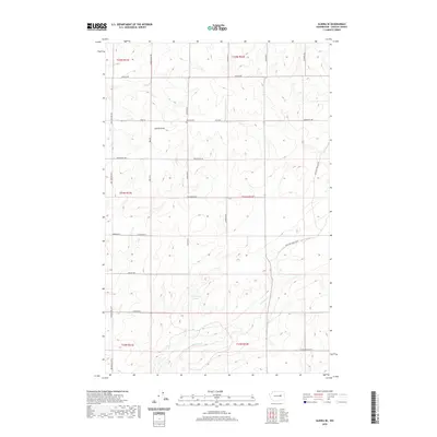
2020 Map of Almira SE
USGS Topo · Published 2020About this map
Tolonen Cem sits at the intersection of Field Rd and Govan Rd N, serving as a silent witness to the generations who farmed this part of Lincoln County. This portion of the Columbia Plateau is characterized by its high-country drainage systems, most notably Gibson Draw and the meandering path of Canniwai Cr as it flows south toward Carpenter Lake. The map reveals a highly structured grid of section lines and gravel roads named for local families, including Rees Rd, Monson Rd, and Schweda Rd. These routes connect isolated farmsteads across the township boundaries of T24N and T25N, illustrating the persistent agricultural patterns of eastern Washington. The absence of concentrated town centers highlights the rural, dispersed nature of life in this corner of the Big Bend country during the early 21st century.
Find a feature on this map
34 named features on this map. Tap any name to fly to it.
Don’t see what you’re looking for? This feature index may not catch every label — zoom into the map to look around manually.
Map Details
Editions of this 2020 Almira SE Map
This is the sole edition of this map. No revisions or reprints were ever made.
Other maps of this area

1953 · Ritzville
USGS Topo · 1:250,000

1959 · Ritzville
USGS Topo · 1:250,000

1965 · Ritzville
USGS Topo · 1:250,000

1968 · Marlin
USGS Topo · 1:24,000

1968 · Pacific Lake
USGS Topo · 1:24,000

1968 · Sullivan Lake
USGS Topo · 1:24,000

1969 · Almira
USGS Topo · 1:24,000

1969 · Almira SE
USGS Topo · 1:24,000
1969 · Almira SW
USGS Topo · 1:24,000

1969 · Govan
USGS Topo · 1:24,000