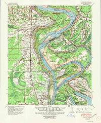
1939 Map of Alsatia
USGS Topo · Published 1957About this map
Mississippi River hydrology dominates this 1930s landscape, where massive engineering projects like the Newman Cut-Off (1913) and Willow Cut-Off (1934) have dramatically reshaped the state border between Louisiana and Mississippi. Along the western bank, the Missouri Pacific railroad anchors a string of agricultural settlements including Alsatia, Sondheimer, and Transylvania. The map provides significant evidence of the river's destructive power and human attempts to contain it, marked by the Hollybrook Crevasse and an extensive network of levees and revetments like the Fitler Revetment. Local history is preserved through numerous family-named boat landings such as Shiloh Ldg and Dogtail Ldg, alongside cultural landmarks like Mt Chapel Ch and several ancient Indian Mounds. The presence of Fitler Bend and the oxbow at Eagle Lake illustrate the transition from active river channels to isolated backwaters in this flood-prone delta region.
Find a feature on this map
75 named features on this map. Tap any name to fly to it.
Don’t see what you’re looking for? This feature index may not catch every label — zoom into the map to look around manually.
Map Details
Editions of this 1939 Alsatia Map
2 editions found

Other maps of this area

1909 · Baxter Bayou
USGS Topo · 1:24,000

1909 · Millikens Bend
USGS Topo · 1:24,000

1909 · Lake Providence
USGS Topo · 1:24,000

1909 · Tallulah
USGS Topo · 1:24,000

1911 · Lake Providence
USGS Topo · 1:31,680

1911 · Baxter Bayou
USGS Topo · 1:24,000

1914 · Baxter Bayou
USGS Topo · 1:31,680

1918 · Vicksburg
USGS Topo · 1:62,500

1935 · Waverly
USGS Topo · 1:62,500

1935 · Oak Grove
USGS Topo · 1:62,500