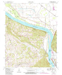
1947 Map of Altenburg
USGS Topo · Published 1990About this map
The Mississippi River creates a dramatic divide through this 1947 landscape, separating the flat bottomlands of Jackson County, Illinois, from the dissected uplands of Perry County, Missouri. Along the western bluffs, German-Lutheran heritage is evident in the proximity of Altenburg, Frohna, and the riverfront settlement of Wittenberg. These communities contrast with the agrarian lowlands of the Fountain Bluff area, where the Neunert community and various river landings like Brunkhorst Landing once served as vital commerce points. The topography reveals a complex network of drainage, from the winding Brazeau Creek to the industrial presence of a Power Plant near the river’s edge. This survey documents a transitional era where traditional river landings and rural schools like Union Sch and Ridge Sch remained central to local life even as modern infrastructure began to alter the river valley.
Find a feature on this map
31 named features on this map. Tap any name to fly to it.
Don’t see what you’re looking for? This feature index may not catch every label — zoom into the map to look around manually.
Map Details
Editions of this 1947 Altenburg Map
4 editions found
Other maps of this area

1910 · Murphysboro
USGS Topo · 1:62,500

1916 · Campbell Hill
USGS Topo · 1:62,500

1918 · Altenburg
USGS Topo · 1:62,500

1918 · Campbell Hill
USGS Topo · 1:62,500

1924 · Alto Pass
USGS Topo · 1:62,500

1925 · Altenburg
USGS Topo · 1:62,500

1938 · Murphysboro
USGS Topo · 1:62,500

1947 · Alto Pass
USGS Topo · 1:62,500

1947 · Crosstown
USGS Topo · 1:24,000

1947 · Oak Ridge
USGS Topo · 1:24,000