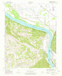
1947 Map of Altenburg
USGS Topo · Published 1978About this map
The Mississippi River creates a dynamic border between Missouri and Illinois on this 1947 survey, where high bluffs meet rich bottomlands. The German heritage of Perry County is anchored by Altenburg and Frohna, while riverfront hamlets like Wittenberg and the curiously named Seventysix provide a look at the region's historical river-and-rail economy. Transportation routes follow the natural topography, with the St Louis San Francisco railroad hugging the river bank beneath the heights of Salem.
Find a feature on this map
44 named features on this map. Tap any name to fly to it.
Don’t see what you’re looking for? This feature index may not catch every label — zoom into the map to look around manually.
Map Details
Editions of this 1947 Altenburg Map
4 editions found
Other maps of this area

1910 · Murphysboro
USGS Topo · 1:62,500

1916 · Campbell Hill
USGS Topo · 1:62,500

1918 · Altenburg
USGS Topo · 1:62,500

1918 · Campbell Hill
USGS Topo · 1:62,500

1924 · Alto Pass
USGS Topo · 1:62,500

1925 · Altenburg
USGS Topo · 1:62,500

1938 · Murphysboro
USGS Topo · 1:62,500

1947 · Alto Pass
USGS Topo · 1:62,500

1947 · Crosstown
USGS Topo · 1:24,000

1947 · Oak Ridge
USGS Topo · 1:24,000