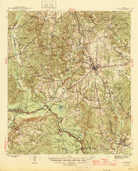
1946 Map of Alto
USGS Topo · Published 1946About this map
Alto serves as the central hub in this post-war survey of East Texas, where the intersection of the St Louis Southwestern RR and the Old San Antonio Road highlights the area's long-standing role as a transport corridor. The landscape is a mix of agricultural progress and deep history, evidenced by the Texas A & M Experimental Station and the Site of Ft Lacy. Significant cultural markers are scattered throughout the hills, including the Delaware Indian Village and Bowles Monument near Larrisson Creek. To the south, the terrain descends into the wooded bottomlands of the Davy Crockett National Forest along the Neches River. Small communities like Weches, Morrill, and Forest are documented alongside numerous family-named landmarks such as Gibson Mtn and Huddleston Pond, offering a detailed view of Cherokee County's mid-century rural structure.
Find a feature on this map
98 named features on this map. Tap any name to fly to it.
Don’t see what you’re looking for? This feature index may not catch every label — zoom into the map to look around manually.
Map Details
Editions of this 1946 Alto Map
2 editions found
Other maps of this area

1943 · Cushing
USGS Topo · 1:62,500

1943 · Rusk
USGS Topo · 1:62,500

1945 · Cushing
USGS Topo · 1:62,500

1945 · Rusk
USGS Topo · 1:62,500

1946 · Alto
USGS Topo · 1:62,500

1950 · Crockett NE
USGS Topo · 1:24,000

1950 · Kennard NE
USGS Topo · 1:24,000

1950 · Ratcliff
USGS Topo · 1:24,000

1951 · Wells
USGS Topo · 1:24,000

1951 · Crockett NE
USGS Topo · 1:24,000