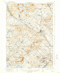
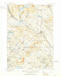
1919 Map of Alton
USGS Topo · Published 1937About this map
Alton Bay marks the southeastern reach of Lake Winnipesaukee, where the Boston and Maine RR met the shoreline at the peak of the region's resort era. This 1917 survey, published as the automobile began to reshape New Hampshire, reveals a landscape of high ridges and narrow valleys defined by the Blue Hills Range and Birch Ridge. The network of early thoroughfares like Ten Rod Road and Wolfeboro Road connects long-established hill settlements such as New Durham and Farmington.
Find a feature on this map
107 named features on this map. Tap any name to fly to it.
Don’t see what you’re looking for? This feature index may not catch every label — zoom into the map to look around manually.
Map Details
Editions of this 1919 Alton Map
6 editions found

Other maps of this area

1891 · Berwick
USGS Topo · 1:62,500

1891 · Newfield
USGS Topo · 1:62,500

1893 · Dover
USGS Topo · 1:62,500

1893 · Berwick
USGS Topo · 1:62,500

1893 · Newfield
USGS Topo · 1:62,500

1909 · Winnepesaukee
USGS Topo · 1:62,500

1916 · Dover
USGS Topo · 1:62,500

1917 · Mt. Pawtuckaway
USGS Topo · 1:62,500

1918 · Dover
USGS Topo · 1:62,500

1919 · Mt. Pawtuckaway
USGS Topo · 1:62,500