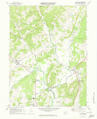
1971 Map of Alum Bank
USGS Topo · Published 1973About this map
Bobs Creek and Dunning Creek carve through the Bedford County landscape, shaping a series of narrow valleys between Chestnut Ridge and Black Oak Ridge. In the early 1970s, this region remained a network of rural settlements like Alum Bank and Osterburg, connected by winding roads and the Penn Central rail line. The presence of several Covered Bridges and the Fish Hatchery near Reynoldsdale highlights a land defined by its water resources and traditional infrastructure.
Find a feature on this map
44 named features on this map. Tap any name to fly to it.
Don’t see what you’re looking for? This feature index may not catch every label — zoom into the map to look around manually.
Map Details
Editions of this 1971 Alum Bank Map
3 editions found
Other maps of this area

1900 · Everett
USGS Topo · 1:62,500

1902 · Everett
USGS Topo · 1:62,500

1902 · Ebensburg
USGS Topo · 1:62,500

1902 · Hollidaysburg
USGS Topo · 1:62,500

1903 · Hollidaysburg
USGS Topo · 1:62,500

1904 · Ebensburg
USGS Topo · 1:62,500

1908 · Bedford
USGS Topo · 1:62,500

1910 · Bedford
USGS Topo · 1:62,500

1953 · Pittsburgh
USGS Topo · 1:250,000

1954 · Pittsburgh
USGS Topo · 1:250,000
Featured Places
- Pavia Township, PA
- Saint Clairsville, PA
- Churchville, East Saint Clair Township
- East Saint Clair Township, PA
- King Township, PA