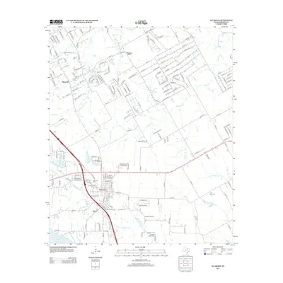
2012 Map of Alvarado
USGS Topo · Published 2012About this map
Alvarado serves as the focal point of this Johnson County landscape, where the convergence of modern transportation corridors meets long-established rural settlements. This survey captures the transition of the northern Texas prairies as residential subdivisions like Happy Hill and Pleasant Point expand amidst a network of creeks and branches. The hydrologic pattern is defined by the N Fork Chambers Cr and Mountain Creek, which feed toward Alvarado Lake in the southwest corner. Local history is deeply embedded in the land through numerous burial sites, including the Glenwood Cem within the town limits and the more remote Center League Cem and Cahill Cem. Aviation history is also noted with the presence of Goodlett Field Airport, illustrating the region's infrastructure development as it balances its agricultural roots with suburban growth.
Find a feature on this map
167 named features on this map. Tap any name to fly to it.
Don’t see what you’re looking for? This feature index may not catch every label — zoom into the map to look around manually.
Map Details
Editions of this 2012 Alvarado Map
This is the sole edition of this map. No revisions or reprints were ever made.
Other maps of this area

1891 · Cleburne
USGS Topo · 1:125,000

1894 · Cleburne
USGS Topo · 1:125,000

1894 · Fort Worth
USGS Topo · 1:125,000

1954 · Dallas
USGS Topo · 1:250,000

1955 · Burleson
USGS Topo · 1:24,000

1958 · Dallas
USGS Topo · 1:250,000

1959 · Britton
USGS Topo · 1:24,000

1959 · Mansfield
USGS Topo · 1:24,000
1959 · Arlington
USGS Topo · 1:62,500

1960 · Keene
USGS Topo · 1:24,000