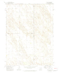
1971 Map of Alvin NE
USGS Topo · Published 1974About this map
Surveyed at the start of the 1970s, this high plains landscape straddles the tri-county corner of Phillips, Yuma, and Chase counties along the Colorado and Nebraska border. The terrain is characterized by a high concentration of groundwater infrastructure, with numerous Well sites distributed across the township sections. These points signify the intensive agricultural development of the region during this era. Industrial activity is represented by a single Gravel Pit, providing a glimpse into the local extraction needed for rural road maintenance. Precise elevation markers such as Bm 3604 and Bm 3572 provide exact data points for geodetic study in an otherwise undulating prairie environment where the three-way intersection of Phillips Co Chase Co and Phillips Co Yuma Co defines the political geography.
Find a feature on this map
8 named features on this map. Tap any name to fly to it.
Don’t see what you’re looking for? This feature index may not catch every label — zoom into the map to look around manually.
Map Details
Editions of this 1971 Alvin NE Map
3 editions found

Other maps of this area

1954 · Sterling
USGS Topo · 1:250,000

1954 · McCook
USGS Topo · 1:250,000

1957 · McCook
USGS Topo · 1:250,000

1958 · McCook
USGS Topo · 1:250,000

1958 · Sterling
USGS Topo · 1:250,000

1961 · Lamar
USGS Topo · 1:24,000

1971 · Amherst SW
USGS Topo · 1:24,000

1971 · Alvin NW
USGS Topo · 1:24,000

1971 · Amherst SE
USGS Topo · 1:24,000

1971 · Alvin SW
USGS Topo · 1:24,000