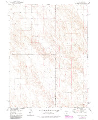
1971 Map of Alvin NE
USGS Topo · Published 1985About this map
The Colorado-Nebraska state line divides this high plains terrain, where the intersection of Phillips and Chase counties meets the boundaries of Phillips and Yuma and Yuma and Chase. The landscape is defined by its agricultural and extractive utility, marked by a solitary Gravel Pit and numerous wells scattered across the undulating contours. Surveyed in the early 1970s and updated with aerial photography in 1980, the map documents the precise placement of benchmark elevations including Bm 3604, Bm 3577, and Bm 3548. This is a sparse, working landscape where fence lines and section boundaries provide the primary structure for land use at the junction of three counties and two states.
Find a feature on this map
9 named features on this map. Tap any name to fly to it.
Don’t see what you’re looking for? This feature index may not catch every label — zoom into the map to look around manually.
Map Details
Editions of this 1971 Alvin NE Map
3 editions found

Other maps of this area

1954 · Sterling
USGS Topo · 1:250,000

1954 · McCook
USGS Topo · 1:250,000

1957 · McCook
USGS Topo · 1:250,000

1958 · McCook
USGS Topo · 1:250,000

1958 · Sterling
USGS Topo · 1:250,000

1961 · Lamar
USGS Topo · 1:24,000

1971 · Amherst SW
USGS Topo · 1:24,000

1971 · Alvin NW
USGS Topo · 1:24,000

1971 · Amherst SE
USGS Topo · 1:24,000

1971 · Alvin SW
USGS Topo · 1:24,000