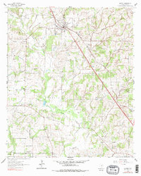
1961 Map of Alvord
USGS Topo · Published 1978About this map
The town of Alvord serves as a central hub on this West Texas survey, situated where the Fort Worth and Denver railroad cuts diagonally through the landscape. The surrounding Wise County terrain is defined by an extensive network of petroleum extraction, including the Jackson Oil Field, Caughlin Oil Field, and the Alvord Southeast Bryson Oil Field. Numerous small country churches and cemeteries, such as Zion Valley Cumberland Ch and Pleasant Grove Cem, are scattered across the watershed of Big Sandy Creek, reflecting the established rural community structure of the mid-20th century. The presence of Old Decatur Road and various gravel pits suggests a local economy balanced between resource extraction and agricultural transport. Genealogists may find particular value in the precise locations of family-named landmarks and remote burial sites like Jonestown Cem.
Find a feature on this map
33 named features on this map. Tap any name to fly to it.
Don’t see what you’re looking for? This feature index may not catch every label — zoom into the map to look around manually.
Map Details
Editions of this 1961 Alvord Map
3 editions found
Other maps of this area

1930 · Boyd
USGS Topo · 1:62,500

1954 · Sherman
USGS Topo · 1:250,000

1958 · Sherman
USGS Topo · 1:250,000

1960 · Bridgeport West
USGS Topo · 1:24,000

1960 · Bridgeport East
USGS Topo · 1:24,000

1960 · Decatur
USGS Topo · 1:24,000

1961 · Pecan Creek
USGS Topo · 1:24,000

1961 · Alvord
USGS Topo · 1:24,000

1961 · New Harp
USGS Topo · 1:24,000

1961 · Sunset
USGS Topo · 1:24,000