Loading...
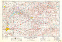
Loading map...1954 Map of Amarillo
USGS Topo · Published 1976About this map
Amarillo and its surrounding High Plains landscape are defined by a convergence of major transportation and industrial corridors in the mid-1970s. The region is bisected by the Atchison Topeka and Santa Fe and the Chicago Rock Island and Pacific railroads, which support the energy and agricultural hubs of Borger, Pampa, and Dumas. Industrial activity is prominent, featuring numerous refineries, carbon black plants, and the expansive USAEC Pantex Plant east of the city.
Find a feature on this map
114 named features on this map. Tap any name to fly to it.
Don’t see what you’re looking for? This feature index may not catch every label — zoom into the map to look around manually.
Map Details
Date Portrayed1954
Date Published1976
PublisherU.S. Geological Survey
Map TypeTopographic
Scale1:250,000
Physical Dimensions31.8 x 21.8 inches
Editions of this 1954 Amarillo Map
2 editions found

Historical Maps of Amarillo Through Time
3 maps found

Featured Locations
Source Details
SourceU.S. Geological Survey
CopyrightPublic Domain