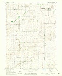
1964 Map of Ambia
USGS Topo · Published 1965About this map
The Illinois-Indiana state line bisects this agricultural landscape, where the town of Ambia stands as a rail hub in the mid-1960s. The region's transport history is visible through several major lines, including the Chicago Milwaukee St Paul and Pacific and the New York Chicago and St Louis railroads. These tracks intersect at small shipping points and settlements like Cheneyville, Powley Corners, and College Corners, which supported the surrounding farms of Hickory Grove and Prairie Green.
Find a feature on this map
23 named features on this map. Tap any name to fly to it.
Don’t see what you’re looking for? This feature index may not catch every label — zoom into the map to look around manually.
Map Details
Editions of this 1964 Ambia Map
This is the sole edition of this map. No revisions or reprints were ever made.
Other maps of this area

1933 · Hoopeston
USGS Topo · 1:48,000

1938 · Milford
USGS Topo · 1:48,000

1938 · Hoopeston
USGS Topo · 1:62,500

1944 · Milford
USGS Topo · 1:62,500

1953 · Danville
USGS Topo · 1:250,000

1955 · Danville
USGS Topo · 1:250,000

1956 · Danville
USGS Topo · 1:250,000

1961 · Tab
USGS Topo · 1:24,000

1961 · West Lebanon
USGS Topo · 1:24,000

1962 · Boswell
USGS Topo · 1:24,000