
1961 Map of West Lebanon
USGS Topo · Published 1964About this map
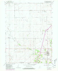
The intersection of the New York Central and Chicago and Eastern Illinois railroads anchors the agricultural landscape of Warren County in the early 1960s. These rail lines supported a network of small grain-handling and residential hubs, including Stewart, Judyville, and Marshfield. The map reveals the local infrastructure of the era, from the storage bins near Stewart to the Seeger Memorial Sch and the southern cluster of West Lebanon. Drainage patterns across the townships of Jordan, Liberty, and Steuben flow toward the Wabash River, which cuts through the southeastern corner. Historical sites like Old Town and Redwood Cem provide essential data for genealogists tracing family roots in this corner of Indiana. The terrain is defined by several creek systems, notably Little Jordan Creek and Redwood Creek, which weave through the farm-to-market road grid.
Find a feature on this map
37 named features on this map. Tap any name to fly to it.
Don’t see what you’re looking for? This feature index may not catch every label — zoom into the map to look around manually.
Map Details
Editions of this 1961 West Lebanon Map
2 editions found
Other maps of this area

1899 · Danville
USGS Topo · 1:62,500

1900 · Danville
USGS Topo · 1:62,500

1933 · Hoopeston
USGS Topo · 1:48,000

1938 · Hoopeston
USGS Topo · 1:62,500

1950 · Danville NE
USGS Topo · 1:24,000

1951 · Danville NE
USGS Topo · 1:24,000

1953 · Danville
USGS Topo · 1:250,000

1955 · Danville
USGS Topo · 1:250,000

1956 · Danville
USGS Topo · 1:250,000

1958 · Stonebluff
USGS Topo · 1:24,000