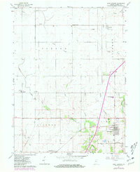
1961 Map of West Lebanon
USGS Topo · Published 1981About this map
The town of West Lebanon serves as a focal point for this survey of Warren County, where the agricultural landscape is divided by the tracks of the Norfolk and Western and Conrail railroads. The map records several small communities and rural junctions, including Judyville, Stewart, and Marshfield, alongside the earlier site of Old Town. Waterways like Redwood Creek and Little Jordan Creek drain the surrounding fields, which are dotted with local landmarks such as Seeger Memorial Sch and Roadside Park. Genealogists will find notable burial sites documented, such as Redwood Cem and Shankland Hill Cem. The inclusion of fine red dashed lines to indicate field boundaries and fence lines, visible in aerial photography, provides an exceptional record of land use and property divisions in this portion of Indiana during the mid-twentieth century.
Find a feature on this map
30 named features on this map. Tap any name to fly to it.
Don’t see what you’re looking for? This feature index may not catch every label — zoom into the map to look around manually.
Map Details
Editions of this 1961 West Lebanon Map
2 editions found

Other maps of this area

1899 · Danville
USGS Topo · 1:62,500

1900 · Danville
USGS Topo · 1:62,500

1933 · Hoopeston
USGS Topo · 1:48,000

1938 · Hoopeston
USGS Topo · 1:62,500

1950 · Danville NE
USGS Topo · 1:24,000

1951 · Danville NE
USGS Topo · 1:24,000

1953 · Danville
USGS Topo · 1:250,000

1955 · Danville
USGS Topo · 1:250,000

1956 · Danville
USGS Topo · 1:250,000

1958 · Stonebluff
USGS Topo · 1:24,000