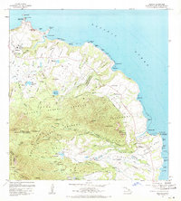
1963 Map of Anahola
USGS Topo · Published 1971About this map
The coastal settlement of Anahola and the northern sugar plantation community of Kilauea anchor this northeast Kauaʻi landscape. Significant cultural and historical sites are documented here, including ancient temples like Kipapa Heiau and Kapinao Heiau, alongside the Spalding Monument. The map reflects a period when the Hawaiian Homes program had established a presence near Anahola Bay, while the Kilauea Sugar Plantation Co. infrastructure, including the Kilauea Flume, remained integral to the local economy.
Find a feature on this map
92 named features on this map. Tap any name to fly to it.
Don’t see what you’re looking for? This feature index may not catch every label — zoom into the map to look around manually.
Map Details
Editions of this 1963 Anahola Map
2 editions found
Other maps of this area

1954 · Kauai
USGS Topo · 1:250,000

1963 · Anahola
USGS Topo · 1:24,000

1963 · Kapaa
USGS Topo · 1:24,000

1963 · Hanalei
USGS Topo · 1:24,000

1965 · Waialeale
USGS Topo · 1:24,000

1967 · Kauai
USGS Topo · 1:250,000

1970 · Kauai
USGS Topo · 1:250,000

1978 · Kapaa
USGS Topo · 1:24,000
1983 · Hanalei
USGS Topo · 1:24,000
1983 · Waialeale
USGS Topo · 1:24,000