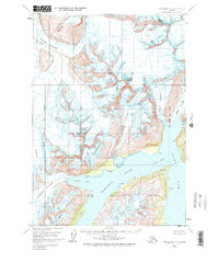
1960 Map of Anchorage A-4
USGS Topo · Published 1974About this map
Chugach National Forest land dominates this 1960 survey, documenting a glacial landscape where massive ice flows meet the saltwater of the Prince William Sound area. The map illustrates the dramatic convergence of numerous glaciers, including the Colony Glacier, Serpentine Glacier, and Stairway Glacier, as they carve through the peaks of the Chugach Mountains. High-altitude landmarks such as Mount Gilbert, Mount Gannett, and Mount Muir overlook the deep waters of Harriman Fiord and Barry Arm. This document captures the mid-century extent of these active ice fields before modern retreat, providing a baseline for geologists and environmental historians studying the Surprise Glacier and Cascade Glacier. The intricate contour work also details the crevassed surfaces and moraine patterns along Doran Strait and Surprise Inlet.
Find a feature on this map
26 named features on this map. Tap any name to fly to it.
Don’t see what you’re looking for? This feature index may not catch every label — zoom into the map to look around manually.
Map Details
Editions of this 1960 Anchorage A-4 Map
3 editions found

Other maps of this area

1951 · Seward
USGS Topo · 1:250,000

1951 · Anchorage
USGS Topo · 1:250,000

1951 · Seward D-5
USGS Topo · 1:63,360

1951 · Seward D-4
USGS Topo · 1:63,360

1951 · Seward D-3
USGS Topo · 1:63,360

1952 · Seward D-5
USGS Topo · 1:63,360

1952 · Seward D-3
USGS Topo · 1:63,360

1952 · Seward D-4
USGS Topo · 1:63,360

1953 · Seward
USGS Topo · 1:250,000

1959 · Seward
USGS Topo · 1:250,000