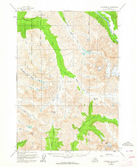
1960 Map of Anchorage A-7
USGS Topo · Published 1964About this map
The Fort Richardson Military Reservation dominates the northwest quadrant of this 1960s topographic study, illustrating the strategic military footprint near Anchorage during the Cold War era. High-altitude recreational features like the Ski Bowl and the connecting Ski Road appear alongside the rugged natural drainage systems of Ship Creek and the South Fork Eagle River. The map meticulously details the glaciated terrain of the Chugach Mountains, including the massive Bird Glacier and notable summits like Suicide Peak. For the researcher, the map preserves the precise alignment of the Seward Meridian and the approximate boundaries of federal land withdrawals. Historic transit through the high country is evidenced by Bird Creek Pass and Indian Creek Pass, providing a clear view of the wilderness landscape before extensive modern trail development and expansion into the front range.
Find a feature on this map
25 named features on this map. Tap any name to fly to it.
Don’t see what you’re looking for? This feature index may not catch every label — zoom into the map to look around manually.
Map Details
Editions of this 1960 Anchorage A-7 Map
5 editions found

Other maps of this area

1951 · Seward
USGS Topo · 1:250,000

1951 · Anchorage
USGS Topo · 1:250,000

1951 · Seward D-8
USGS Topo · 1:63,360

1951 · Seward D-7
USGS Topo · 1:63,360

1951 · Seward D-6
USGS Topo · 1:63,360

1952 · Seward D-8
USGS Topo · 1:63,360

1952 · Seward D-6
USGS Topo · 1:63,360

1952 · Seward D-7
USGS Topo · 1:63,360

1952 · Anchorage A-8
USGS Topo · 1:63,360

1952 · Anchorage B-8
USGS Topo · 1:63,360