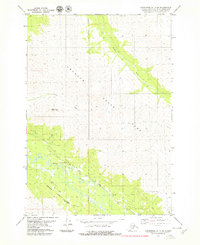
1979 Map of Anchorage B-7 SE
USGS Topo · Published 1979About this map
Chugach State Park dominates this 1970s topographic record, where the high ridges of Mount Magnificent oversee a landscape of deep valleys and shifting glacial drainage. The Eagle River snakes through the southern portion of the quadrangle, paralleled by the Lower Eagle River Trail, while Peters Creek and Meadow Creek cut significant paths through the northeast. This era of mapping shows the transition of the Anchorage periphery into a preserved wilderness area, with the Seward Meridian providing the primary survey control for the surrounding municipal lands. The map emphasizes the natural drainage patterns and elevation contours that have long dictated the expansion of the Anchorage basin.
Find a feature on this map
8 named features on this map. Tap any name to fly to it.
Don’t see what you’re looking for? This feature index may not catch every label — zoom into the map to look around manually.
Map Details
Editions of this 1979 Anchorage B-7 SE Map
2 editions found
Other maps of this area

1951 · Anchorage
USGS Topo · 1:250,000

1960 · Anchorage A-6
USGS Topo · 1:63,360

1960 · Anchorage B-7
USGS Topo · 1:63,360

1960 · Anchorage B-6
USGS Topo · 1:63,360

1960 · Anchorage A-7
USGS Topo · 1:63,360

1962 · Anchorage
USGS Topo · 1:250,000

1979 · Anchorage B-6 NW
USGS Topo · 1:25,000

1979 · Anchorage B-7 SW
USGS Topo · 1:25,000
1979 · Anchorage B-7 NE
USGS Topo · 1:25,000

1979 · Anchorage
USGS Topo · 1:250,000