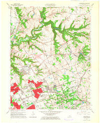
1965 Map of Anchorage
USGS Topo · Published 1966About this map
The suburban expansion of eastern Jefferson County is evident in this mid-1960s survey, where new residential developments like Briarwood and Plantation press against large institutional grounds. The landscape is defined by massive state and educational complexes, including the Central State Hospital and the Ormsby Village State Reservation. Historic institutions such as the Kentucky Military Institute and St Thomas Seminary represent the area's long-standing role as a center for education and clergy training. Along the northern edge, Harrods Creek and its South Fork wind through deep valleys, providing a natural buffer between the growing city and the more rural terrain of the Oldham County line. The Louisville and Nashville railroad serves as a central spine through the map, connecting older communities like Anchorage and O'Bannon with the industrializing corridors near St. Matthews.
Find a feature on this map
86 named features on this map. Tap any name to fly to it.
Don’t see what you’re looking for? This feature index may not catch every label — zoom into the map to look around manually.
Map Details
Editions of this 1965 Anchorage Map
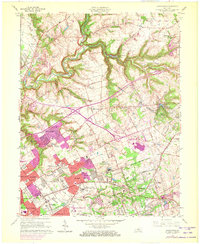
2 editions found
Other maps of this area

1905 · Prospect
USGS Topo · 1:62,500

1907 · Louisville
USGS Topo · 1:62,500

1912 · Prospect
USGS Topo · 1:62,500

1929 · Taylorsville
USGS Topo · 1:62,500

1932 · La Grange
USGS Topo · 1:62,500

1937 · Jeffersonville
USGS Topo · 1:24,000

1937 · Charlestown
USGS Topo · 1:24,000

1938 · Owen
USGS Topo · 1:24,000

1946 · Jeffersonville
USGS Topo · 1:24,000

1948 · Owen
USGS Topo · 1:24,000