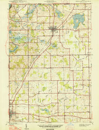
1947 Map of Angola East
USGS Topo · Published 1947About this map
Glacial lakes and rural town centers define the northeastern corner of Steuben County in the late 1930s. The village of Fremont serves as a northern hub, situated near the intersection of the New York Central railroad and an extensive network of local ditches including the Bruce Ryan Ditch and Eatinger Ditch. These waterways reflect the effort to manage the marshy landscape of the Northern Indiana Lake Country, which is dotted with numerous bodies of water like Lake George on the Michigan Indiana border and the expansive Cedar Lake to the east.
Find a feature on this map
38 named features on this map. Tap any name to fly to it.
Don’t see what you’re looking for? This feature index may not catch every label — zoom into the map to look around manually.
Map Details
Editions of this 1947 Angola East Map
2 editions found
Other maps of this area

1939 · Hamilton
USGS Topo · 1:24,000

1939 · Angola East
USGS Topo · 1:24,000

1939 · Clear Lake
USGS Topo · 1:24,000

1940 · Metz
USGS Topo · 1:24,000

1940 · Clear Lake
USGS Topo · 1:24,000

1941 · Angola West
USGS Topo · 1:24,000

1942 · Ashley
USGS Topo · 1:24,000

1942 · Angola West
USGS Topo · 1:24,000

1947 · Angola East
USGS Topo · 1:24,000

1948 · Hamilton
USGS Topo · 1:24,000