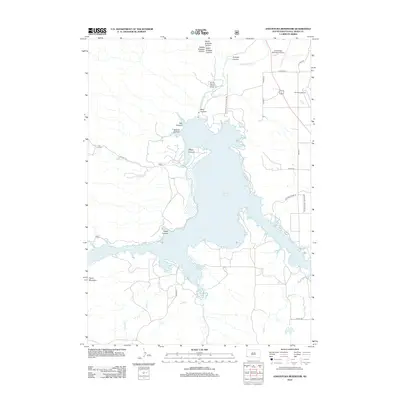
2012 Map of Angostura Reservoir
USGS Topo · Published 2012About this map
Angostura Reservoir dominates the landscape of southern Fall River County, formed by the impoundment of the Cheyenne River. The 2012 survey illustrates the rugged drainage systems that feed the reservoir, including the complex network of Knappie Canyon and several prominent draws such as Horse Camp Draw and Wall Canyon. To the west, the topography rises toward Tepee Mountain, while the northern portion of the quadrangle shows the operational infrastructure of the Hot Springs Municipal Airport and the agricultural footprint of the Fall River Feedyard. Local transit is anchored by roads like Angustura State Park Rd and Riff Raff Ridge Rd, which provide access to the recreational and residential areas developed around the shoreline, including Sheps Canyon and Adams Canyon.
Find a feature on this map
31 named features on this map. Tap any name to fly to it.
Don’t see what you’re looking for? This feature index may not catch every label — zoom into the map to look around manually.
Map Details
Editions of this 2012 Angostura Reservoir Map
This is the sole edition of this map. No revisions or reprints were ever made.
Other maps of this area

1896 · Oelrichs
USGS Topo · 1:125,000

1900 · Oelrichs
USGS Topo · 1:125,000

1902 · Edgemont
USGS Topo · 1:125,000

1950 · Hot Springs
USGS Topo · 1:24,000

1950 · Buffalo Gap
USGS Topo · 1:24,000

1950 · Heppner
USGS Topo · 1:24,000

1950 · Cascade Springs
USGS Topo · 1:24,000

1950 · Hot Springs SE
USGS Topo · 1:24,000

1950 · Angostura Reservoir
USGS Topo · 1:24,000

1951 · Minnekahta NE
USGS Topo · 1:24,000