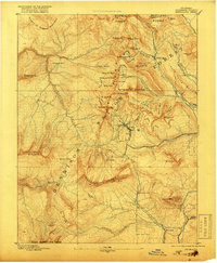
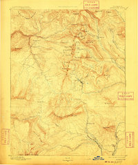
1893 Map of Anthracite
USGS Topo · Published 1918About this map
Mining settlements and high-altitude passes define this high-country landscape during the late nineteenth-century silver and coal boom. The neighboring towns of Irwin and Ruby sit near Marcellina Pass and the Kubler Mine, serving as vital hubs for the surrounding extraction efforts. To the north, the remote mining camp of Pittsburgh lies at the junction of Poverty Gulch and the Slate River, while Elkton is established further east. These camps were connected by a network of precarious mountain routes, including Daisy Pass and Ohio Pass, which allowed for the movement of people and ore through the Anthracite Range.
Find a feature on this map
67 named features on this map. Tap any name to fly to it.
Don’t see what you’re looking for? This feature index may not catch every label — zoom into the map to look around manually.
Map Details
Editions of this 1893 Anthracite Map
9 editions found
Other maps of this area

1888 · Crested Butte
USGS Topo · 1:62,500

1888 · Anthracite
USGS Topo · 1:62,500

1889 · Crested Butte
USGS Topo · 1:62,500

1889 · Anthracite
USGS Topo · 1:62,500

1893 · Anthracite
USGS Topo · 1:62,500

1893 · Crested Butte
USGS Topo · 1:62,500

1893 · Aspen
USGS Topo · 1:62,500

1894 · Anthracite
USGS Topo · 1:62,500

1895 · Aspen
USGS Topo · 1:62,500

1909 · Mount Jackson
USGS Topo · 1:125,000