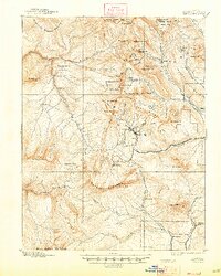
1893 Map of Anthracite
USGS Topo · Published 1947About this map
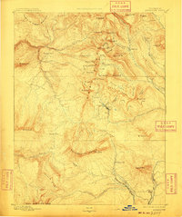
Anthracite Range and the surrounding high-altitude terrain dominate this late nineteenth-century landscape, surveyed during the peak of Colorado's mining era. High mountain settlements like Irwin and Ruby sit tucked between the Peeler Basin and the peaks of the White River Nat For, illustrating the remote and specialized nature of extraction in Gunnison County. The map traces the industrial reach of the period, from the isolated Floresta to the active Kubler Mine near Mt Carbon P.O.. High mountain passes such as Daisy Pass and Marcellina Pass provide the primary links through this terrain, connecting basins like Swan Basin to the drainage of Anthracite Creek and the Slate River. This survey reveals the intense localization of the mining economy, where every peak from Oh-be-joyful Peak to Gothic Mt was a landmark for prospecting and transport.
Find a feature on this map
72 named features on this map. Tap any name to fly to it.
Don’t see what you’re looking for? This feature index may not catch every label — zoom into the map to look around manually.
Map Details
Editions of this 1893 Anthracite Map
9 editions found
Other maps of this area

1888 · Crested Butte
USGS Topo · 1:62,500

1888 · Anthracite
USGS Topo · 1:62,500

1889 · Crested Butte
USGS Topo · 1:62,500

1889 · Anthracite
USGS Topo · 1:62,500

1893 · Anthracite
USGS Topo · 1:62,500

1893 · Crested Butte
USGS Topo · 1:62,500

1893 · Aspen
USGS Topo · 1:62,500

1894 · Anthracite
USGS Topo · 1:62,500

1895 · Aspen
USGS Topo · 1:62,500

1909 · Mount Jackson
USGS Topo · 1:125,000