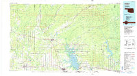
1985 Map of Antlers
USGS Topo · Published 1985About this map
Antlers sits at the heart of this mid-1980s landscape, serving as a hub for the rail and road networks of Pushmataha County. The Burlington Northern railroad corridor traces a path through established timber and cattle country, connecting smaller settlements like Moyers, Kosoma, and Eubanks. To the west, the Indian Nation Turnpike provides a modern contrast to the older winding routes that follow the Impson Valley.
Find a feature on this map
122 named features on this map. Tap any name to fly to it.
Don’t see what you’re looking for? This feature index may not catch every label — zoom into the map to look around manually.
Map Details
Editions of this 1985 Antlers Map
2 editions found
Other maps of this area

1896 · Coalgate
USGS Topo · 1:125,000

1898 · McAlester
USGS Topo · 1:125,000

1899 · Coalgate
USGS Topo · 1:125,000

1899 · Atoka
USGS Topo · 1:125,000

1900 · Atoka
USGS Topo · 1:125,000

1900 · Coalgate
USGS Topo · 1:125,000

1900 · Winding Stair
USGS Topo · 1:125,000

1901 · Antlers
USGS Topo · 1:125,000

1901 · Tuskahoma
USGS Topo · 1:125,000

1901 · Alikchi
USGS Topo · 1:125,000