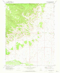
1970 Map of Antone Canyon
USGS Topo · Published 1973About this map
The Book Cliffs dominate this eastern Utah landscape, forming a dramatic escarpment that defines the northern geography of Grand County. In the early 1970s, this area was characterized by a remote industrial and ranching economy, evidenced by the presence of a Gas Field and several scattered Drill Holes. The drainage patterns are intricate, with seasonal watercourses like Cottonwood Wash and Antone Wash carving through the arid terrain. Local landmarks such as Cato Springs provided critical water points in an otherwise thirsty environment. The map details a network of primitive Jeep Trails and unnamed Trails that offered the only access into the deep recesses of Antone Canyon and Buck Canyon, illustrating the isolation of the high desert before modern infrastructure reached these canyons.
Find a feature on this map
16 named features on this map. Tap any name to fly to it.
Don’t see what you’re looking for? This feature index may not catch every label — zoom into the map to look around manually.
Map Details
Editions of this 1970 Antone Canyon Map
2 editions found
Other maps of this area

1885 · East Tavaputs
USGS Topo · 1:250,000

1954 · Westwater 4 SW
USGS Topo · 1:24,000

1956 · Grand Junction
USGS Topo · 1:250,000

1959 · Grand Junction
USGS Topo · 1:250,000

1960 · Grand Junction
USGS Topo · 1:250,000

1962 · Grand Junction
USGS Topo · 1:250,000

1964 · Grand Junction
USGS Topo · 1:250,000

1965 · Grand Junction
USGS Topo · 1:250,000
1970 · Harley Dome
USGS Topo · 1:24,000

1970 · Flume Canyon
USGS Topo · 1:24,000