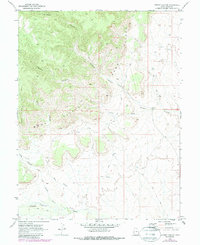
1970 Map of Antone Canyon
USGS Topo · Published 1987About this map
The Book Cliffs dominate this eastern Utah landscape, forming a massive escarpment that dictates the movement of water and travelers alike. At the transition from the high plateau to the desert floor, a network of drainages including Sulphur Canyon and Antone Canyon carve through the sedimentary layers, converging toward Sulphur Creek. This 1970 survey, later updated with mid-1980s aerial data, reveals a workspace of the modern era where resource extraction and traditional land use meet. Scattered Drill Holes on the upper benches indicate geological exploration, while the presence of Cato Springs and various named washes like Cottonwood Wash and Buck Canyon highlight the critical importance of water sources in this arid environment. Navigation is limited to a sparse network of a Jeep Trail and primitive footpaths that follow the natural contours of the canyon floors and cliff edges.
Find a feature on this map
22 named features on this map. Tap any name to fly to it.
Don’t see what you’re looking for? This feature index may not catch every label — zoom into the map to look around manually.
Map Details
Editions of this 1970 Antone Canyon Map
2 editions found
Other maps of this area

1885 · East Tavaputs
USGS Topo · 1:250,000

1954 · Westwater 4 SW
USGS Topo · 1:24,000

1956 · Grand Junction
USGS Topo · 1:250,000

1959 · Grand Junction
USGS Topo · 1:250,000

1960 · Grand Junction
USGS Topo · 1:250,000

1962 · Grand Junction
USGS Topo · 1:250,000

1964 · Grand Junction
USGS Topo · 1:250,000

1965 · Grand Junction
USGS Topo · 1:250,000
1970 · Harley Dome
USGS Topo · 1:24,000

1970 · Flume Canyon
USGS Topo · 1:24,000