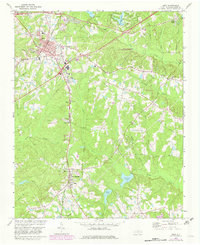
1974 Map of Apex
USGS Topo · Published 1982About this map
Apex and Holly Springs anchor this detailed study of southern Wake County during a period of transition as rural land gave way to burgeoning suburban development. The town of Apex is centered on its rail heritage at the intersection of the Seaboard Coast Line and the Durham and Southern railroads, with a local street grid including Chatham St and Moore St. Downward from the town center, the landscape is defined by the headwaters of numerous creeks, including Williams Creek and Utley Creek, and the presence of significant community landmarks like the Baucom Sch and True Way Ch. To the south, the settlement at Holly Springs sits amidst a network of ponds and lakes, most notably Sunset Lake and Bass Lake. Genealogists will find interest in the numerous rural cemeteries and small community anchors such as Matthew Chapel and St Marys Ch located along the winding country roads.
Find a feature on this map
46 named features on this map. Tap any name to fly to it.
Don’t see what you’re looking for? This feature index may not catch every label — zoom into the map to look around manually.
Map Details
Editions of this 1974 Apex Map
5 editions found

Other maps of this area

1943 · Durham South
USGS Topo · 1:62,500

1943 · Raleigh
USGS Topo · 1:62,500

1951 · Raleigh
USGS Topo · 1:62,500

1951 · Durham South
USGS Topo · 1:62,500

1953 · Raleigh
USGS Topo · 1:250,000

1954 · Raleigh
USGS Topo · 1:250,000

1964 · Lake Wheeler
USGS Topo · 1:24,000

1964 · Angier
USGS Topo · 1:24,000

1964 · Garner
USGS Topo · 1:62,500

1968 · Raleigh West
USGS Topo · 1:24,000