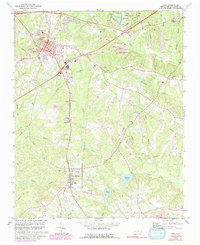
1974 Map of Apex
USGS Topo · Published 1992About this map
The town of Apex serves as a primary hub for this mid-1970s survey of Wake County, showing a period of transition as suburban expansion begins to meet established rural communities. The map documents the footprint of Holly Springs to the south and the small settlement of Feltonville along the Old Railroad Grade. This era is marked by the presence of numerous neighborhood institutions, including Matthew Chapel, St Marys Ch, and Baucom Sch.
Find a feature on this map
47 named features on this map. Tap any name to fly to it.
Don’t see what you’re looking for? This feature index may not catch every label — zoom into the map to look around manually.
Map Details
Editions of this 1974 Apex Map
5 editions found

Other maps of this area

1943 · Durham South
USGS Topo · 1:62,500

1943 · Raleigh
USGS Topo · 1:62,500

1951 · Raleigh
USGS Topo · 1:62,500

1951 · Durham South
USGS Topo · 1:62,500

1953 · Raleigh
USGS Topo · 1:250,000

1954 · Raleigh
USGS Topo · 1:250,000

1964 · Lake Wheeler
USGS Topo · 1:24,000

1964 · Angier
USGS Topo · 1:24,000

1964 · Garner
USGS Topo · 1:62,500

1968 · Raleigh West
USGS Topo · 1:24,000