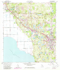
1960 Map of Apopka
USGS Topo · Published 1981About this map
Lake Apopka defines the southwestern edge of this landscape, its vast shoreline bordering the agricultural expanse of Zellwood Farms Road. The area is characterized by a high density of named water bodies, including Lake Maggiore, Lake Francis, and Wolf Lake, interspersed with citrus groves and clay mining operations as indicated by several Claypit labels. Transportation and industry are anchored by the Seaboard Coast Line railroad, which links the established citrus centers of Zellwood, Plymouth, and Apopka. Local history is preserved through numerous institutions like Hampden Dubose Academy and the Douglas Sch, while the presence of the Orlando North Airport and several pumping stations highlights the mid-century infrastructure required to manage this lake-rich Florida terrain. The eastern edge transitions into the protected landscape of Wekiwa Springs State Park, centered around the natural Rock Springs area.
Find a feature on this map
89 named features on this map. Tap any name to fly to it.
Don’t see what you’re looking for? This feature index may not catch every label — zoom into the map to look around manually.
Map Details
Editions of this 1960 Apopka Map
4 editions found
Other maps of this area

1955 · Orlando
USGS Topo · 1:250,000

1956 · Winter Garden
USGS Topo · 1:24,000

1956 · Orlando West
USGS Topo · 1:24,000

1957 · Orlando
USGS Topo · 1:250,000

1958 · Orlando
USGS Topo · 1:250,000

1959 · Forest City
USGS Topo · 1:24,000

1960 · Sorrento
USGS Topo · 1:24,000

1960 · Apopka
USGS Topo · 1:24,000

1962 · Orlando
USGS Topo · 1:250,000

1962 · Clermont East
USGS Topo · 1:24,000