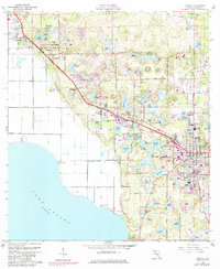
1960 Map of Apopka
USGS Topo · Published 1984About this map
Lake Apopka's eastern shore defines this Central Florida landscape, where a transition from citrus agriculture to suburban expansion is visible through 1977 aerial revisions. The Seaboard Coast Line railroad anchors a chain of settlements including Zellwood, Plymouth, and the larger hub of Apopka. In these communities, local life centered around institutions like the Hampden Dubose Academy and churches such as St Lukes Ch and New Jerusalem Ch.
Find a feature on this map
91 named features on this map. Tap any name to fly to it.
Don’t see what you’re looking for? This feature index may not catch every label — zoom into the map to look around manually.
Map Details
Editions of this 1960 Apopka Map
4 editions found
Other maps of this area

1955 · Orlando
USGS Topo · 1:250,000

1956 · Winter Garden
USGS Topo · 1:24,000

1956 · Orlando West
USGS Topo · 1:24,000

1957 · Orlando
USGS Topo · 1:250,000

1958 · Orlando
USGS Topo · 1:250,000

1959 · Forest City
USGS Topo · 1:24,000

1960 · Sorrento
USGS Topo · 1:24,000

1960 · Apopka
USGS Topo · 1:24,000

1962 · Orlando
USGS Topo · 1:250,000

1962 · Clermont East
USGS Topo · 1:24,000