
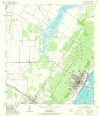
1954 Map of Aransas Pass
USGS Topo · Published 1956About this map
Aransas Pass and Ingleside serve as the primary hubs on this coastal landscape, situated along the interface of Redfish Bay and the interior. The industrial character of the mid-1950s is evident in the extensive Aransas Pass Oil Field and the Tank Farm near the Southern Pacific tracks. Between the settlements, Live Oak Ridge provides a distinct topographic contrast to the low-lying marshes surrounding Mc Campbell Slough and Spears Lake.
Find a feature on this map
39 named features on this map. Tap any name to fly to it.
Don’t see what you’re looking for? This feature index may not catch every label — zoom into the map to look around manually.
Map Details
Editions of this 1954 Aransas Pass Map
2 editions found
Other maps of this area

1925 · Aransas Pass
USGS Topo · 1:62,500

1925 · Corpus Christi
USGS Topo · 1:62,500

1950 · Corpus Christi
USGS Topo · 1:250,000

1951 · Portland
USGS Topo · 1:24,000

1951 · Corpus Christi
USGS Topo · 1:62,500

1953 · Beeville
USGS Topo · 1:250,000

1954 · Rockport
USGS Topo · 1:62,500

1954 · Port Ingleside
USGS Topo · 1:24,000

1954 · Woodsboro
USGS Topo · 1:62,500

1954 · Estes
USGS Topo · 1:24,000