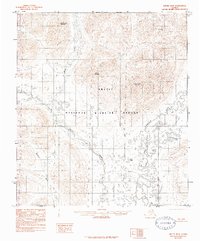
1983 Map of Arctic B-3
USGS Topo · Published 1984About this map
The Arctic National Wildlife Refuge dominates this sub-arctic landscape, where high peaks and braided river systems define the terrain. The northern reaches are characterized by the elevations of Water Creek Mountain, Yasuda Mountain, and Nichenthraw Mountain, which shed water into the drainages of Water Creek and Deadman Creek. The map provides a detailed view of the hydrology within the North Slope Borough before more modern satellite imagery, showing the intricate path of the Junjik River as it moves toward its confluence.
Find a feature on this map
12 named features on this map. Tap any name to fly to it.
Don’t see what you’re looking for? This feature index may not catch every label — zoom into the map to look around manually.
Map Details
Editions of this 1983 Arctic B-3 Map
3 editions found
Other maps of this area

1951 · Arctic
USGS Topo · 1:250,000

1956 · Arctic
USGS Topo · 1:250,000

1972 · Arctic A-3
USGS Topo · 1:63,360
1972 · Arctic A-4
USGS Topo · 1:63,360

1972 · Arctic A-2
USGS Topo · 1:63,360
1983 · Arctic B-4
USGS Topo · 1:63,360

1983 · Arctic C-3
USGS Topo · 1:63,360

1983 · Arctic B-2
USGS Topo · 1:63,360

1983 · Arctic C-2
USGS Topo · 1:63,360

1983 · Arctic B-3
USGS Topo · 1:63,360