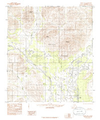
1983 Map of Arctic B-3
USGS Topo · Published 1986About this map
Arctic National Wildlife Refuge encompasses this expansive high-latitude landscape, where the Junjik River flows through the central valley to meet the East Fork Chandalar River. This 1983 provisional survey shows a wilderness devoid of roads or permanent settlements, defined instead by the hydrologic network of Deadman Creek and Water Creek. Significant topographic landmarks like Yasuda Mountain, Nichenthraw Mountain, and Water Creek Mountain rise above a series of remote water bodies, including Tinjik Lake, Noah Lake, and Below Tree Lake. The map serves as a primary record of the northern interior's drainage patterns and unnamed topographical features as they were understood during the late twentieth-century expansion of federal conservation efforts in the North Slope Borough.
Find a feature on this map
13 named features on this map. Tap any name to fly to it.
Don’t see what you’re looking for? This feature index may not catch every label — zoom into the map to look around manually.
Map Details
Editions of this 1983 Arctic B-3 Map
3 editions found
Other maps of this area

1951 · Arctic
USGS Topo · 1:250,000

1956 · Arctic
USGS Topo · 1:250,000

1972 · Arctic A-3
USGS Topo · 1:63,360
1972 · Arctic A-4
USGS Topo · 1:63,360

1972 · Arctic A-2
USGS Topo · 1:63,360
1983 · Arctic B-4
USGS Topo · 1:63,360

1983 · Arctic C-3
USGS Topo · 1:63,360

1983 · Arctic B-2
USGS Topo · 1:63,360

1983 · Arctic C-2
USGS Topo · 1:63,360

1983 · Arctic B-3
USGS Topo · 1:63,360