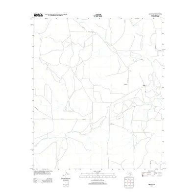
2012 Map of Arden
USGS Topo · Published 2012About this map
Arden serves as the focal point of this Irion County landscape, situated where the high plains meet the winding course of the Middle Concho River. The settlement's local history is anchored by the Arden Cem, located north of the town center along Funk Ranch Rd. This 2012 survey illustrates a classic West Texas ranching geography, defined by a network of named tracks such as Bates Rd and Mertz Rd that navigate the seasonal drainages of W Rocky Cr and Dry Rocky Cr. The drainage patterns, including the prominent Dry Cr, reveal the hydrology of the Concho Valley, where water is the primary driver of road placement and land use. The presence of Ranch Road 853 provides a glimpse into the modern transit corridors that connect these isolated ranching communities to the broader region.
Find a feature on this map
18 named features on this map. Tap any name to fly to it.
Don’t see what you’re looking for? This feature index may not catch every label — zoom into the map to look around manually.
Map Details
Editions of this 2012 Arden Map
This is the sole edition of this map. No revisions or reprints were ever made.
Other maps of this area

1895 · Sherwood
USGS Topo · 1:125,000

1928 · Tankersly
USGS Topo · 1:62,500

1954 · San Angelo
USGS Topo · 1:250,000

1957 · Carlsbad
USGS Topo · 1:62,500

1957 · Knickerbocker
USGS Topo · 1:62,500

1958 · San Angelo
USGS Topo · 1:250,000

1965 · San Angelo
USGS Topo · 1:250,000

1972 · Arden
USGS Topo · 1:24,000

1972 · Wallace Draw
USGS Topo · 1:24,000
1972 · Mertzon SW
USGS Topo · 1:24,000