
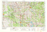
1957 Map of Ardmore
USGS Topo · Published 1968About this map
The Arbuckle Mountains dominate the south-central Oklahoma landscape in this mid-century survey, rising as a distinct geological heart between the developing plains. The massive expanse of Lake Texoma and the Tishomingo National Wildlife Refuge define the southeastern corner, reflecting the era’s significant water management and conservation efforts along the Washita River and Red River. The map captures a complex transport network of railroads including the Atchison Topeka & Santa Fe RR and Chicago Rock Island & Pacific RR, which connect established hubs like Ardmore, Duncan, and Ada.
Find a feature on this map
265 named features on this map. Tap any name to fly to it.
Don’t see what you’re looking for? This feature index may not catch every label — zoom into the map to look around manually.
Map Details
Editions of this 1957 Ardmore Map
3 editions found
Other maps of this area

1893 · Norman
USGS Topo · 1:62,500

1896 · Seminole and Prague
USGS Topo · 1:125,000

1896 · Coalgate
USGS Topo · 1:125,000

1898 · Purcell
USGS Topo · 1:125,000

1898 · McAlester
USGS Topo · 1:125,000

1898 · Pauls Valley
USGS Topo · 1:125,000

1899 · Coalgate
USGS Topo · 1:125,000

1899 · Atoka
USGS Topo · 1:125,000

1900 · Canadian
USGS Topo · 1:125,000

1900 · Wewoka
USGS Topo · 1:125,000