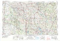
1957 Map of Ardmore
USGS Topo · Published 1978About this map
The Arbuckle Mountains dominate the central landscape of this southern Oklahoma region, providing a topographic backdrop to the river-rich plains where the Washita River and Blue River flow toward Lake Texoma. This mid-century survey illustrates a complex transition from agrarian river valleys to the industrial presence of numerous Oil wells and the Naval Ammunition Depot near the eastern boundary. Major regional hubs like Pauls Valley, Wynnewood, and Ada are shown as established centers of commerce and transport. The map highlights a robust infrastructure of railroads including the At&Sf Rr and SL-SF RR, which historically facilitated the movement of cattle, agriculture, and oil. Public lands like the Chickasaw Nat Rec Area and Lake Murray State Park underscore the area's development for recreation alongside its heavy industry.
Find a feature on this map
249 named features on this map. Tap any name to fly to it.
Don’t see what you’re looking for? This feature index may not catch every label — zoom into the map to look around manually.
Map Details
Editions of this 1957 Ardmore Map
3 editions found

Other maps of this area

1893 · Norman
USGS Topo · 1:62,500

1896 · Seminole and Prague
USGS Topo · 1:125,000

1896 · Coalgate
USGS Topo · 1:125,000

1898 · Purcell
USGS Topo · 1:125,000

1898 · McAlester
USGS Topo · 1:125,000

1898 · Pauls Valley
USGS Topo · 1:125,000

1899 · Coalgate
USGS Topo · 1:125,000

1899 · Atoka
USGS Topo · 1:125,000

1900 · Canadian
USGS Topo · 1:125,000

1900 · Wewoka
USGS Topo · 1:125,000