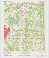
1964 Map of Ardmore East
USGS Topo · Published 1977About this map
The city of Ardmore serves as the focal point for this mid-1960s study, displaying a dense urban grid that transitions into the rolling creek bottoms of southern Oklahoma. Educational landmarks like Will Rogers Sch and Washington Sch anchor the neighborhood developments, while the municipal infrastructure includes a Sewage Disposal facility and a Radio Tower. To the east, the landscape opens into the rural townships of Morgan and Wilson, where family life centered around rural institutions like Springdale Ch and Niblack Chapel.
Find a feature on this map
43 named features on this map. Tap any name to fly to it.
Don’t see what you’re looking for? This feature index may not catch every label — zoom into the map to look around manually.
Map Details
Editions of this 1964 Ardmore East Map
4 editions found
Other maps of this area

1901 · Tishomingo
USGS Topo · 1:125,000

1901 · Ardmore
USGS Topo · 1:125,000

1918 · Ardmore
USGS Topo · 1:125,000

1957 · Ardmore
USGS Topo · 1:250,000

1963 · Ardmore
USGS Topo · 1:250,000

1963 · Mannsville
USGS Topo · 1:24,000

1963 · Mc Millan
USGS Topo · 1:24,000

1963 · Nebo
USGS Topo · 1:24,000

1964 · Lake Murray
USGS Topo · 1:24,000

1964 · Ardmore East
USGS Topo · 1:24,000