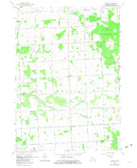
1963 Map of Argyle
USGS Topo · Published 1982About this map
Austin Center and Argyle anchor this rural landscape in the early 1960s, a region defined by its extensive drainage network and small-town infrastructure. The map reveals a high concentration of local schools including Argyle Sch, Starr Sch, Wheeler Sch, and McBride Sch, indicating a well-populated agricultural community at the time of the 1963 field check. The eastern edge is dominated by the Minden City State Game Area, while the central terrain is carved by the Middle Branch Cass River and various man-made channels like Hobbs Drain and Franzel Drain. Genealogists will find value in the placement of community landmarks like Freidberger church and several burial grounds, including Mt Pleasant Cem and Wheatland Cem. The grid of county roads, such as Argyle Road and Deckerville Road, connects these dispersed settlements and gravel pits, reflecting the area's mid-century rural economy.
Find a feature on this map
44 named features on this map. Tap any name to fly to it.
Don’t see what you’re looking for? This feature index may not catch every label — zoom into the map to look around manually.
Map Details
Editions of this 1963 Argyle Map
2 editions found

Other maps of this area

1954 · Flint
USGS Topo · 1:250,000

1958 · Flint
USGS Topo · 1:250,000

1963 · Snover
USGS Topo · 1:24,000

1963 · New Greenleaf
USGS Topo · 1:24,000

1963 · Sandusky
USGS Topo · 1:24,000

1963 · Ubly
USGS Topo · 1:24,000

1963 · Minden City
USGS Topo · 1:24,000

1963 · Palms
USGS Topo · 1:24,000

1963 · Shabbona
USGS Topo · 1:24,000
1963 · Decker
USGS Topo · 1:24,000