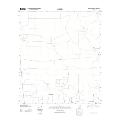
2013 Map of Arizona Creek
USGS Topo · Published 2013About this map
Ducat Settlement and Vanva Settlement anchor this portrait of the Liberty County hinterlands, where small communities persist amidst a landscape defined by sluggish waterways and thick timber. The drainage of Arizona Cr and the winding Pine Island Bayou dictate the area's geography, feeding into wetlands like Black Land Slough and Mayhaw Slough. Evidence of the region’s long-standing connection to the petroleum industry is visible through labels like Omniex Oil and the E Batson Mainline, while the Big Thicket Loblolly conservation area preserves a piece of the native ecosystem. The road network, including the evocative Old School House Rd and Buzzard Rd, suggests a rural life organized around old property lines and natural drainages like Batiste Cr and Long Island Cr.
Find a feature on this map
34 named features on this map. Tap any name to fly to it.
Don’t see what you’re looking for? This feature index may not catch every label — zoom into the map to look around manually.
Map Details
Editions of this 2013 Arizona Creek Map
This is the sole edition of this map. No revisions or reprints were ever made.
Other maps of this area

1943 · Liberty
USGS Topo · 1:125,000

1954 · Beaumont
USGS Topo · 1:250,000

1955 · Daisetta
USGS Topo · 1:62,500

1955 · Saratoga
USGS Topo · 1:62,500

1955 · Rayburn
USGS Topo · 1:62,500

1955 · Liberty
USGS Topo · 1:62,500

1957 · Beaumont
USGS Topo · 1:250,000

1984 · Beaumont
USGS Topo · 1:250,000
1984 · Saratoga
USGS Topo · 1:24,000
1984 · Arizona Creek
USGS Topo · 1:24,000