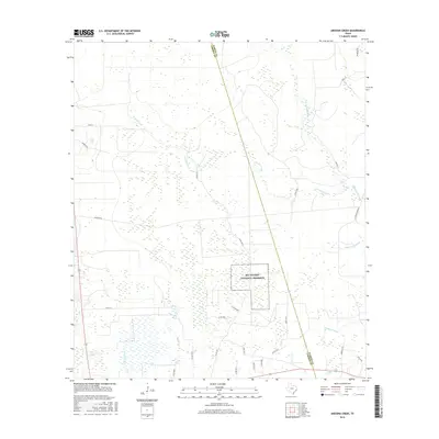
2016 Map of Arizona Creek
USGS Topo · Published 2016About this map
Big Thicket National Preserve anchors the landscape of this 2016 survey, where the dense wetlands of Southeast Texas are meticulously charted. The map illustrates a complex drainage network dominated by Arizona Creek and Pine Island Bayou, alongside smaller water bodies like Batiste Cr and the seasonally flooded Black Land Slough. This region, crossing the boundary between Hardin and Liberty counties, is defined by its low-lying terrain and a grid of rural roads and timber tracks. Industry and access are represented by features such as Omninex Oil and the E Batson Mainline, reflecting the ongoing balance between natural preservation and the local extraction and timber economies. Genealogists and historians can trace local family or place names through thoroughfares like Buzzard Rd and Murray J Rd that wind through the thickets.
Find a feature on this map
30 named features on this map. Tap any name to fly to it.
Don’t see what you’re looking for? This feature index may not catch every label — zoom into the map to look around manually.
Map Details
Editions of this 2016 Arizona Creek Map
This is the sole edition of this map. No revisions or reprints were ever made.
Other maps of this area

1943 · Liberty
USGS Topo · 1:125,000

1954 · Beaumont
USGS Topo · 1:250,000

1955 · Daisetta
USGS Topo · 1:62,500

1955 · Saratoga
USGS Topo · 1:62,500

1955 · Rayburn
USGS Topo · 1:62,500

1955 · Liberty
USGS Topo · 1:62,500

1957 · Beaumont
USGS Topo · 1:250,000

1984 · Beaumont
USGS Topo · 1:250,000
1984 · Saratoga
USGS Topo · 1:24,000
1984 · Arizona Creek
USGS Topo · 1:24,000