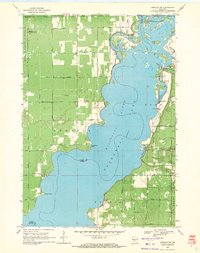
1969 Map of Arkdale NW
USGS Topo · Published 1971About this map
Petenwell Lake dominates this landscape on the border of Juneau and Adams counties, shaped by the massive flow of the Wisconsin River. The settlement of New Rome sits on the eastern shore near Twin Lakes, supported by a local New Rome Ch and a nearby Community Hall. The topography reveals a mix of recreational and military land use, with Petenwell Wilderness Park and Monroe Park bordering the water, while the western portion of the township of Armenia is occupied by the National Guard Bombing and Gunnery Range.
Find a feature on this map
32 named features on this map. Tap any name to fly to it.
Don’t see what you’re looking for? This feature index may not catch every label — zoom into the map to look around manually.
Map Details
Editions of this 1969 Arkdale NW Map
3 editions found
Other maps of this area

1953 · Eau Claire
USGS Topo · 1:250,000

1955 · Green Bay
USGS Topo · 1:250,000

1957 · Wisconsin Rapids
USGS Topo · 1:48,000

1957 · Pittsville
USGS Topo · 1:48,000

1958 · Eau Claire
USGS Topo · 1:250,000

1958 · Arkdale
USGS Topo · 1:48,000

1958 · Necedah
USGS Topo · 1:48,000

1964 · Eau Claire
USGS Topo · 1:250,000

1967 · Roche A Cri
USGS Topo · 1:24,000

1967 · Arkdale NE
USGS Topo · 1:24,000