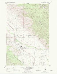
1984 Map of Arlee
USGS Topo · Published 1984About this map
The Jocko Valley landscape of the mid-1980s is defined by the convergence of mountain waters and transportation corridors within the Flathead Indian Reservation. At the heart of the map, the settlement of Arlee serves as a primary hub, featuring a High Sch, a Rodeo Ground, and a nearby Fish Hatchery. The Burlington Northern railroad and a major Pipeline parallel the course of Finley Creek, tracing the valley floor toward the Jocko River. Higher elevations to the north and east are marked by the rugged drainage basins of Lamoose Creek and Pistol Creek, where the Lookout Tower stands as a sentinel over the surrounding timber. The mapping of Gravel Pits and various canals indicates an active local infrastructure supporting both the reservation and the adjacent Lake and Missoula County borderlands.
Find a feature on this map
26 named features on this map. Tap any name to fly to it.
Don’t see what you’re looking for? This feature index may not catch every label — zoom into the map to look around manually.
Map Details
Editions of this 1984 Arlee Map
2 editions found
Other maps of this area

1921 · Elbow Lake
USGS Topo · 1:125,000

1955 · Choteau
USGS Topo · 1:250,000

1956 · Wallace
USGS Topo · 1:250,000

1957 · Choteau
USGS Topo · 1:250,000

1958 · Choteau
USGS Topo · 1:250,000

1959 · Arlee
USGS Topo · 1:62,500

1960 · Wallace
USGS Topo · 1:250,000

1962 · Choteau
USGS Topo · 1:250,000

1964 · Saint Ignatius
USGS Topo · 1:24,000

1964 · Ravalli
USGS Topo · 1:24,000